8. Coordination
Coordination is one of the key ATAP Framework principles (see Part A1 Overview, Section 3). In ITLUP, coordination plays a particularly crucial role. It requires coordination between planning for the three transport infrastructure types and coordination in institutional settings and governance.
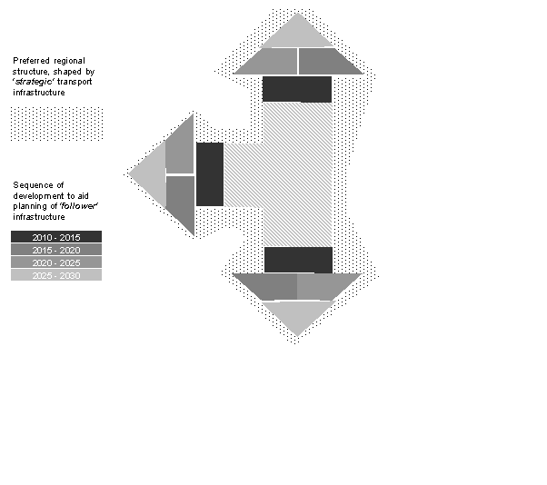
Infrastructure coordination will maximise the combined potential benefits of both land use and transport. Figure 20 illustrates the relationship between the phasing of strategic infrastructure versus structural/local infrastructure in an effective coordination system. Strategic infrastructure is leveraged to help bring about a metropolitan settlement pattern for optimal economic, social and environmental outcomes. Structural and local infrastructure is then managed via a spatial sequencing process that addresses the risks associated with fragmented or out of sequence development.
Figure 20: Relationship between ‘Strategic’ ‘Structural and Local’ Infrastructure in city planning
Source: SGS Economics and Planning Pty Ltd
Nowadays, development is generally encouraged to occur in a manner that leads to consolidated urban growth and is coordinated with the provision of infrastructure being delivered.
Some jurisdictions specifically do not allow out-of-sequence developments at all. Other jurisdictions may, in some cases, allow developers to undertake out-of-sequence initiatives. In such cases, developers should ideally meet the cost of advancing infrastructure. This would send a higher price signal for that development compared with more consolidated urban growth. The strongest signal would be sent if developers had to face the full cost of advancing infrastructure that is required as a result of out-of-sequence development.
8.1 Principles
An effective cross sector coordination system should address institutional arrangements to:
- Harness the city shaping power of key transport initiatives to ensure the city gets the most advantageous strategic infrastructure package (rather than unduly reflecting inertia in initiative planning and funding streams)
- Facilitate coordination of structural and local infrastructure to contain inventory costs by, in effect, fostering a just-in-time approach.
8.2 Strategic infrastructure
Once metropolitan governance resolves tensions in the first iteration of a plan for strategic initiatives (the strategic plan), a similar process should be repeated to test the merits of subsequent strategic infrastructure identified after the strategic plan is finalised. On the other hand, local infrastructure is managed via a development sequencing framework.
The rationale behind these ongoing appraisals should be broadly consistent with that for the initial version of a strategic infrastructure plan. Figure 21 outlines the principles and processes involved in the ongoing coordination of strategic infrastructure.
Figure 21: A model for coordinating strategic infrastructure
Source: Adapted from Spiller et al 2012The additional economic scrutiny placed on strategic infrastructure initiatives could involve the creation of a range of investment scenarios or packages.
The CBA process will ultimately produce a preferred package of strategic infrastructure initiatives that, among other things, best supports the metropolitan planning framework for the city.
The process outlined in Figure 21 can be affected through centralised coordination institutions or agencies responsible for infrastructure planning. However, as discussed earlier, clarity and authority about the desired city structure at the metropolitan level is essential and requires strong metropolitan planning governance. In the case of distributed investment planning, all proponents of potentially strategic initiatives would be encouraged to undertake a self-assessment of their plans under this logic. This would then be appraised and debated within an appropriate metropolitan governance framework.
The funding and financing of infrastructure is a significant consideration in relation to the coordination of strategic infrastructure and an important area for future potential expansion of the ATAP Guidelines.
8.3 Structural or local infrastructure
The main objective for structural or local infrastructure is to coordinate the timing and delivery of transport and land use. This requires some form of market-based development sequencing that identifies a preferred pathway for development in a planning district, based on minimising the total cost of social and economic infrastructure.
Although most obviously applicable in greenfield growth areas, the concept of a preferred pathway for development is equally relevant in established urban areas undergoing progressive redevelopment or wholesale regeneration. The idea is for the appropriate state or local authority to make a reasonable forecast of the pattern and timing of development (and, implicitly, the pattern and timing of demand for infrastructure services) and then adopt this as the notional benchmark for services planning by all infrastructure and service delivery agencies.
The benchmark sequence of development would be reviewed regularly (for example, every year) and as required, particularly if new information comes to hand on land demand or as out-of-sequence development approvals alter a district’s geography or infrastructure capacity.
There are several examples across Australia where an out-of-sequence developer fully funded accelerated infrastructure, with the local authority either buying back the facility at the relevant time or collecting contributions from intervening developments and passing these back to the original developer without interest. The innovation in the context of an effective cross-portfolio coordination system would be to codify these practices to ensure consistency across the city and across all infrastructure providers.
8.4 Governance
Coordination within and across levels of government, and between government and the private sector, is an important requirement for achieving effective outcomes in all areas of economic, social and environmental activity. Effective governance is a central element in those processes.
Governance arrangements can have a significant impact on the coordination of ITLUP. Governance arrangements are critical to linking all parties together, developing a shared vision and, most importantly, providing infrastructure to enable the vision to become a reality. Delivering successful ITLUP requires a detailed understanding of the existing governance arrangements that operate in the relevant state or territory.
The experience across Australia varies, with some states and territories combining the planning and transport infrastructure agencies into one department - for example, the South Australian Department of Planning, Transport and Infrastructure. In most jurisdictions, planning and transport departments remain separate, which can restrict the ability to coordinate strategies as well as initiatives. This is particularly apparent when considering that the South Australian Government has released an integrated transport and land use plan (see box below), while most other states and territories have separate planning and transport strategies.
Coordination is also required between and with health and education departments, as these authorities can help to identify the appropriate sites for new facilities, particularly in greenfield areas.
Vertical coordination between the Australian Government, state/territory governments and local governments is an important driver of ITLUP. State/territory and local governments are often heavily involved in the land use planning process and are critical to integrating local and corridor level infrastructure into the public domain and identifying opportunities to support the infrastructure initiatives through zoning and other land use controls.
The Australian Government has a role in ITLUP through the funding of infrastructure initiatives and in relation to the management of ports and airports, alongside responsibilities for setting the framework for investment in a number of sectors that impact on ITLUP. Badgerys Creek Airport is an example of a strategic initiative that requires coordination from all three levels of government.
Box 2: South Australia Draft Integrated Land use and Transport Plan
The emphasis on integration and the role of land use planning is (intentionally) evident from the front page and title: ‘Integrated Transport and Land Use Plan’ (ITLUP), not ‘Transport Masterplan’ or ‘Transport Plan’. There is a clear focus on aligning the South Australian Government’s land use vision and transport plan.
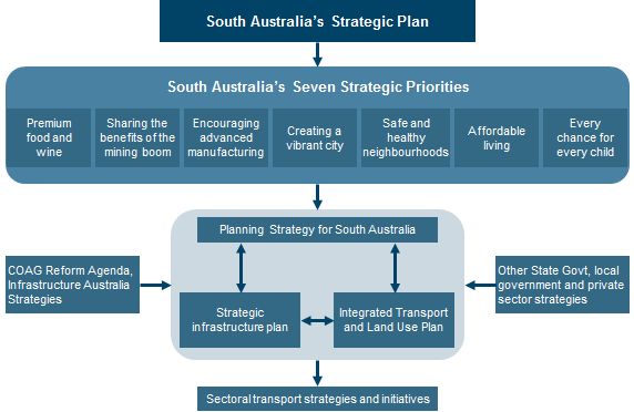
Integration occurs at the highest state-wide strategic planning level. Readers are immediately guided to read ITLUP alongside the SA Planning Strategy and the SA Infrastructure Plan (see diagram below), placing the Plan’s initiatives within a clear strategic context.
The integration of land use planning was a fundamental principle adopted in the development of the Plan. Land use planning was recognised as a key input and given a dedicated workstream within the development process. This ensured that land use planning objectives were captured in every aspect of the Plan’s development: from setting goals and objectives through to defining the challenges and solutions and drafting and presenting the document. The dedicated team appointed to draft the ITLUP also included experienced land use planners.
Importantly, the Plan is intended to also inform subsequent revisions of the Planning Strategy, creating a feedback loop to ensure integration between land use and transport specific plans.
The delivery of the Plan focuses on putting in place the right regulatory framework. Subject to the consideration of an Expert Panel undertaking a review of South Australia’s planning legislation, this framework proposes to bind the Plan to the South Australian Planning Strategy. The Plan also proposes improved governance arrangements that align multiple levels of government planning with the delivery of land use/transport outcomes.
Badgerys Creek (NSW)
In April 2014 the Australian Government announced that Badgerys Creek would be the site for the proposed Western Sydney Airport. A new airport along with supportive land use changes, transport and other infrastructure investment will be a major generator of economic activity for the region, providing employment opportunities closer to home for Western Sydney’s growing population and catering for increasing aviation demand. Effective coordination across all levels of government (Australian, NSW and local governments) will be required to ensure the benefits of Western Sydney Airport can be achieved. This provides the opportunity to reshape and strengthen the economy of outer Western Sydney and better connect it into the global economy.
In terms of supporting infrastructure, the Australian and NSW governments have committed over $3.6 billion to road upgrades to connect the Western Sydney Airport site to Sydney’s road network. The Western Sydney Infrastructure Plan (see Figure 22) will improve road transport capacity and will be completed before airport operations are anticipated to commence in the mid-2020s. Roads are one part of the transport solution; the other is rail.
The Australian and NSW governments have identified that the integration of the future rail network in Western Sydney and effective transport connections to a Western Sydney Airport are essential to accommodate planned growth in the area and to facilitate connectivity within the region and with Greater Sydney. Further, the early planning for the Western Sydney Airport site has allowed for the future integration of rail on the airport site to service the transport needs of people visiting Western Sydney Airport and those working at the airport.
The Australian Government is working closely with the NSW Government to ensure the Western Sydney Airport project is coordinated with state and local government planning. The Greater Sydney Commission and NSW Department of Planning and Environment are coordinating land use development in surrounding precincts, particularly the Western Sydney Priority Growth Area, Western Sydney Employment Area and South West Priority Land release area (see Figure 22).
The Western Sydney Airport development and its associated surface transport linkages have the power to shape Sydney and transform the economic trajectory of Western Sydney. Realising the full social and economic benefits of this development will be conditional on the willingness and capacity of all three levels of government to develop a shared vision and clear priorities around land use planning and infrastructure investment. In this respect, it will be critical that the land use strategies complement the operation of the airport and avoid developments that would be incompatible with the expansion of the airport in the decades ahead.
Figure 22: Western Sydney airport site and infrastructure
Source: Department of Infrastructure and Regional Development, 2015


